Fresh Very Large Avalanche Paradise Divide

CB Avalanche Center2018-19 Observations

Location: Paradise Divide Area
Date of Observation: 03/30/2019
Name: Evan Ross

Subject: Fresh Very Large Avalanche Paradise Divide
Aspect: North East, South East, South West
Elevation: 9,500-12,940

Avalanches:

Skier triggered a very small surface slab just off a high summit and some sluffing. All easy to manage and small in size.

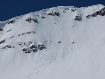
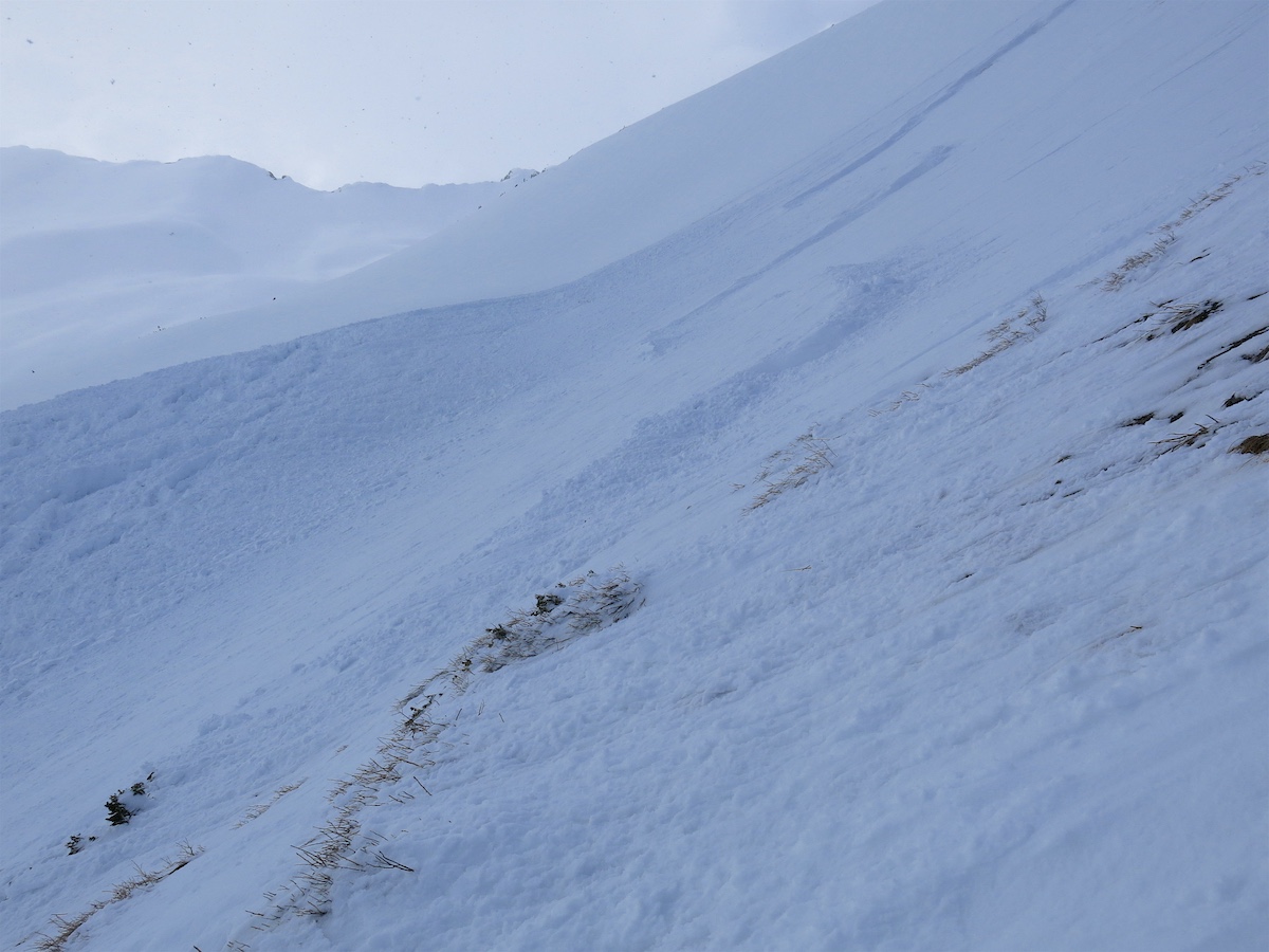
The outlier: I came across a freshly triggered very large avalanche on the way home. S to SW aspect at about 11,800ft. A snowmobile track entered and exited this very large avalanche. The track appeared to go through a thin spot in the slab near some bushes and raised ground. The track further appeared to have splatted on the crown face but had enough momentum to keep going up. I checked out two parts of the crown that were near where the snowmobile track exited. The first was to the lookers right. HS was thin and about 80cm. Basal depth hoar was massive and estimated at 5mm. An ice lens capped these facets and they were also moist. The next quick crown profile was closer at about 20 ft to the looker right of where the track exited. Here HS was 180cm. The crown was 90cm. The basal facets where smaller, also moist and again an ice lens capped these facets. The avalanche appeared to have failed at this ice lens or at the interface with the basal facets. Shortly after getting to that location water started running like a faucet out of the new/old snow interface and I quickly packed up and left. Slope angles were estimated to be near 40 degrees where the snowmobile track left the crown. Crown hight averaged an estimated 70cm. The crown appeared to propagate into a deeper snowpack area.

Weather: Partly Cloudy over the greater forecast area, but my face will tell you that I was in an area that was in the sun all day. Convective clouds where moving very slow, keeping some areas in the clouds and other hanging in the sun all day. Calm winds. Strong Solar.

Snowpack: The March sun was doing its thing and warming snow surfaces. Storm totals were only about 1″ down in the valleys and about 5 to 6″ at upper elevations. The new snow posed little avalanche issues. Sluffing in steep terrain and some deeper drifts to stay mindful of.

Red Lady Glades

CB Avalanche Center2018-19 Observations

Location: Crested Butte Area
Date of Observation: 03/29/2019
Name: ADB

Subject: Red Lady Glades
Aspect: South
Elevation: BTL
Snowpack: Snow Survey at Keystone:

Depth 62 inches or 5 feet
SWE: 22 inches
Density: 30%

Ice lens near the ground.

West Brush Below Treeline Observations (Grand Traverse Course)

CB Avalanche Center2018-19 Observations

Location: Brush Creek Area
Date of Observation: 03/27/2019
Name: Ian Havlick

Subject: West Brush Below Treeline Observations (Grand Traverse Course)
Aspect: East, South East, South, South West
Elevation: 8500-9500

Avalanches:

no avalanches triggered, however thought with the collapses I observed/triggered so close to steep terrain that remote triggering could be possible. Did observe D2 Gibson Ridge wet slab failing between 1300-1530 yesterday. Steep, easterly BTL terrain that previously slid this year. Also numerous fresh glide avalanches low angle, east facing in Brush Creek, on Mt. CB massif.

Weather: Extremely warm, t-shirt weather, no gloves even on snowmobile. Light SW breeze but barely noticeable. Intense solar despite high clouds. Thicker cirrus around 1500.

Snowpack: Only traveled southerly BTL in Brush Creek yesterday. Boot pen was 20cm off skis, but if “dropped weight” foot would plunge to ground.- illustrating pronounced slab structure remains intact. Traveled intentionally late in the afternoon to observe characteristics of wet, warm snowpack. Snowpack is wet, large grains in upper 30cm, and below that, remains colder, moist, finer grained more midwinter snowpack. Numerous rolling collapses, dropping 3-5cm in places and propagating over 200ft on 20º terrain.

Photos:

Large Avalanche Debris on Cement Creek Rd

CB Avalanche Center2018-19 Observations

Location: Cement Creek Area
Date of Observation: 03/27/201

Subject: Avalanche Debris on Cement Creek Rd
Aspect: East, South East
Elevation: ~9,300ft

Avalanches:

Wet Avalanche Debris on Cement Creek Rd in the lower pinch, above the campground. From the observer: “Looked like it started in the cliffs. Didn’t see an obvious crown.

Other Than Surface Issues, The Deep Snowpack Was Holding Up Ok.

CB Avalanche Center2018-19 Observations

Location: Paradise Divide Area
Date of Observation: 03/27/2019
Name: Evan Ross

Subject: Other Than Surface Issues, The Deep Snowpack is Holding Up Well.
Aspect:
Elevation: 9,500-12,500

Weather: The high temperatures can speak for themselves. The high clouds thicker in the afternoon helping to cap the warming, but they may have helped green house some slopes. At the highest elevations traveled winds were generally light, with some moderate gusts. Couple rumbles of Thunder in the late afternoon.

Snowpack: More or less the same story on a different day. The snow surface is transitioning, so there appeared to be less natural loose wet avalanche activity today. However wet snow could still be human triggered on steep slopes in the upper 30 degree range. A wet or moist snow surface is making its rounds at all elevations and has stretched into some NE slopes.

Never ran into something that felt like Wet Slab conditions. The layer of snow deposited by the early March Storm is thick, strong and will need time for water to move through it. Probably going to need a shallow snowpack area like a repeater avalanche slope or steep cliffy terrain, or other below average thin snowpack areas, somewhere that water can get through that otherwise thick layer of snow.

Dug in a very snow favored part of our forecast zone. 28 degree, South aspect at about 10,700ft. Protected slope that felt like a solar oven. HS 275. Wet snow was down to 40 cm, with boot pen close to the same at 1pm. Below that wet snow there was a couple of ~3cm layers of large grain moist snow in the next 30 cm’s of the snowpack. The 2/28 interface was non problematic and 110cm’s below the snow surface.

Dug again in Washington Gulch on the flank of Gothic Mountain. SSW aspect, 28 degree slope, 10400ft. HS 305. Wet snow was down ~25cm and again boot pen was similar. There were some thin ice lenses in the upper snowpack, but again the water was far from impacting the deeply buried 2/28 interface.

Grand Traverse Friends Hut Obs

CB Avalanche Center2018-19 Observations

Location: Brush Creek Area
Date of Observation: 03/26/2019
Name: Ian Havlick

Subject: Grand Traverse Friends Hut Obs
Aspect: North, North East, South, South West, West
Elevation: 10-12,000

Avalanches:

No recent avalanches but team relayed that Timbered Hill 3 ran as big as anyone had ever seen it and extended trim lines during the early March avalanche Cycle.

Weather: overcast, SW winds 20G30, warm!

Snowpack: wet snow surfaces and moistening snow ATL, but only at surface. SW winds kept warming minimal. Norths stayed cold.

Photos:

Standard Wet Loose, Or Great Skiing

CB Avalanche Center2018-19 Observations

Location: Paradise Divide Area
Date of Observation: 03/26/2019
Name: Evan Ross

Subject: Standard Wet Loose, Or Great Skiing
Aspect: North, East, South, West
Elevation: 9,500-12,400

Avalanches:

The wet loose natural cycle had hit East, South and West yesterday at all elevations, and that same theme continued today. Easterly slopes were producing more Wet Loose Avalanches then southerly slopes and we were not out late enough to see what happened today vs yesterday on west. This avalanche problem was generally small and easy to manage, but sure would suck to get caught up in.

Weather: Warm, good solar, and some high thin clouds building by late morning. Calm to light winds.

Snowpack: Same same. The 30cm sitting on the 3/21 interface is cold and a really good time on north. On East, South and West the snow surface was crusty in the morning and became wet with wet loose avalanche issues as the snow warmed. Pulled the prob out once during the climb of a westerly facing bowl above treeline and on the backside of the Ruby Mountains. HS low in the terrain feature was 325cm. Climbing higher into a craggy steep starting zone the HS decreased to the 240-280cm range.

West Brush Below Treeline Observations (Grand Traverse Course)

CB Avalanche Center2018-19 Observations

Location: Brush Creek Area
Date of Observation: 03/25/2019
Name: Ian Havlick

Subject: West Brush Below Treeline Observations (Grand Traverse Course)
Aspect: East, South East, South, South West
Elevation: 9-10,000

Avalanches:

Observed 4-6 D1 wet loose avalanches near treeline on southeasterly Whetstone near cliff bands mid afternoon yesterday. otherwise no recent significant activity noted

Weather: Warm day, fog dissipating by 1300. Mild temperatures, but did remain in 20s until midday. The fog increased “greenhousing” along edges of cold pool and increased snow warming, but in the valley bottoms where fog was thickest, fog kept lid on warming until it burned off. Winds were light and variable, but at higher elevations, did look like snow was being blown around on Whetstone form the west.

Snowpack: Continues to transition to a large grained, spring snowpack at lower elevations and terrain traveled today, but lower elevations southerlies are not quite there with plumbing established to move water quickly through the snowpack. In an 80cm profile near West Brush creek, the upper half was large grained and consistent hardness, but the lower portions of the profile were moist, smaller grained, still closer to winter-like snow. It was the densest portion of the profile that was resting immediately above very weak, unconsolidated grains near the ground. Wet slab structure is not striking, but does look like it has characteristics that could produce wet slab during warm afternoons. Some informal shovel shears to check structure revealed moderate but clean failures mid-pack, and near the ground. Did not take time for compression tests as the snowpack was rapidly warming and changing and did not feel test scores would be super relevant at later times of day.
Photos:

Cold Then Hot. Pow Then Wet.

CB Avalanche Center2018-19 Observations

Location: Paradise Divide Area
Date of Observation: 03/25/2019
Name: Eric Murrow, Evan Ross

Subject: Cold Then Hot. Pow Then Wet.
Aspect: East, South, South West
Elevation: 9,500-12,500

Avalanches:

Few old Wind Slabs out there. Maybe a D2 in the Purple Palace area and near Treasury on easterly and southeasterly slopes. Otherwise small in size, and not too many observed.

Loose wet avalanches are back and making their rounds.  Activity was all on the south half of the compass with a few coming out of hot, rocky east aspects near treeline.  All small in size and didn’t observe any D2’s. For a D2 you would need bigger terrain or for the avalanche to gouge deeper into wet snow.

Skier triggered a very small wet, Wind Slab below treeline on a south aspect at 2pm on a steep short drifted feature.

Weather: Valley fog in CB and lower valleys during the morning. Blue Bird in the Alpine. Moderate westerly winds at upper elevations.

Snowpack: 20-30cm’s of snow on the 3/21 interface. No signs to instability in the upper snowpack. Kept an eye out for thicker wind drifts. Warming temps and wet snow was the main concern.

Photos:

Ruby Range Wind Slabs

CB Avalanche Center2018-19 Observations

Location: Kebler Pass Area
Date of Observation: 03/23/2019
Name: Evan Ross

Subject: Ruby Range Wind Slabs
Aspect: East, South East
Elevation: 9,200-11,300

Weather: The clouds did not part and low level moisture continued to produce snowflakes. Winds were gusting and drifting snow. Storm totals where around 10″ on the Ruby Bench in the early afternoon.

Snowpack: The 10″ HST was holding up well on the old crusty snow surfaces facing east and west. Shooting cracks were observed and small Wind Slabs were triggered on wind-loaded terrain near treeling elevations. Managing the terrain traveled for small Wind Slab Avalanches, while conditions in the alpine appeared more concerning. The next time the sun comes out and warms things up, the loose wet avalanche concerns will be back on the table.